
Kenya National Parks are controlled by Kenya Wildlife Services who
look after and protect the areas. The wages of workers in the National
Parks are usually funded by entrance fees charged for safaris and tours.
Unlike Animal Reserves, National Parks allow strictly no human
habitation. Kenyan national parks are a common tourist attraction in
Kenya.
 The Arabuko Sokoke Forest Reserve is located on the coast of Kenya,
110 km north of Mombasa and is protected as a national Forest Reserve.
The Arabuko Sokoke National Park,
situated at the north-western edge of the Arabuko Sokoke Forest
Reserve, is only a few square kilometres in size and constitutes only a
small portion of the latter.
The Arabuko Sokoke Forest Reserve is located on the coast of Kenya,
110 km north of Mombasa and is protected as a national Forest Reserve.
The Arabuko Sokoke National Park,
situated at the north-western edge of the Arabuko Sokoke Forest
Reserve, is only a few square kilometres in size and constitutes only a
small portion of the latter.
<script data-ad-client="ca-pub-7190135829801849" async src="https://pagead2.googlesyndication.com/pagead/js/adsbygoogle.js"></script>
The Forest Reserve, on the other hand, is jointly managed by the Kenya Forest Service, Kenya Wildlife Service, National Museums of Kenya and the Kenya Forest Research Institute and is one of the better protected forests in Kenya. The forest was first protected as a Crown Forest in 1943, and was gazetted in the 1960s. The forest is threatened by the desire for land by local people. Several national and international conservation organisations are working with the Kenya Wildlife Service to protect the park.
 The Arabuko Sokoke Forest is an area of high endemism,
containing endemic mammals, birds and plants. It contains three forest
types, mixed forest, Brachystegia and Cynometra, each of which protects different communities of plants and animals.
The Arabuko Sokoke Forest is an area of high endemism,
containing endemic mammals, birds and plants. It contains three forest
types, mixed forest, Brachystegia and Cynometra, each of which protects different communities of plants and animals.


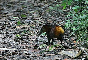
 The endearing golden-rumped elephant shrew, an endemic elephant shrew
the size of a rabbit, is the most noticeable of the park's endemic
mammals; the Sokoke bushy-tailed mongoose and Aders's duiker (found only
here and in Zanzibar) are more elusive. The forest also has savannah
elephants, African civets, as well as sokokes, baboons and vervet
monkeys. The park is also recognised as an outstanding centre of
amphibian diversity.
The endearing golden-rumped elephant shrew, an endemic elephant shrew
the size of a rabbit, is the most noticeable of the park's endemic
mammals; the Sokoke bushy-tailed mongoose and Aders's duiker (found only
here and in Zanzibar) are more elusive. The forest also has savannah
elephants, African civets, as well as sokokes, baboons and vervet
monkeys. The park is also recognised as an outstanding centre of
amphibian diversity.
<script data-ad-client="ca-pub-7190135829801849" async src="https://pagead2.googlesyndication.com/pagead/js/adsbygoogle.js"></script>
National parks
- Aberdare National Park
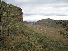
The Aberdare National Park is a protected area in the Aberdare Mountain Range in central Kenya located east of the East African Rift Valley. It covers the higher areas and the Aberdare Salient to
The park is located about 100 km north of Nairobi and stretches over a wide variety of terrain at altitudes from 2,000 metres (6,600 ft) to 4,000 metres (13,000 ft). Established in May 1950, the Aberdare National Park covers an area of 766 square kilometers and forms part of the Aberdare Mountain Range. The park contains a wide range of landscapes - from mountain peaks that rise to 4,000 metres (13,000 ft) above sea level, to their deep, v-shaped valleys intersected by streams, rivers, and waterfalls. Moorland, bamboo forests and rainforests are found at lower altitudes.
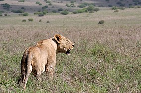
Wildlife present in the protected area include lion, leopard, elephant, East African wild dog, giant forest hog, bushbuck, mountain reedbuck, waterbuck, Cape buffalo, suni, side-striped jackal, eland, duiker, olive baboon, black and white colobus monkey, and sykes monkey. Rarer sightings include those of the African golden cat and the bongo. Species such as the common eland, serval live in the higher moorlands. The Aberdare National Park also hosts a large eastern black rhinoceros population and over 250 bird species including the endangered Aberdare cisticola, Jackson's francolin, sparrowhawk, African goshawk, African fish eagle, sunbirds and plovers.Facilities
Visitors to the park can find different types of accommodation, from the Treetops lodge, to the Ark - built in the shape of Noah's Ark - and three self-help banda sites, eight special campsites and a public campsite in the moorland. There are also five picnic sites. Both Treetops and The Ark provide excellent nighttime wildlife viewing. Animals seen include Elephants, Cape buffalo, and rhino, which come to the waterholes. The park also includes two airstrips at Mweiga and Nyeri.
<script data-ad-client="ca-pub-7190135829801849" async src="https://pagead2.googlesyndication.com/pagead/js/adsbygoogle.js"></script>
Amboseli National Park
formerly Maasai Amboseli Game Reserve, is in Kajiado County, Kenya. The park is 39,206 hectares (392 km2; 151 sq mi) in size at the core of an 8,000 km2 (3,100 sq mi) ecosystem that spreads across the Kenya-Tanzania border. The local people are mainly Maasai, but people from other parts of the country have settled there attracted by the successful tourist-driven economy and intensive agriculture along the system of swamps that makes this low-rainfall area, average 350 mm (14 in), one of the best wildlife-viewing experiences in the world with 400 species of birds including water birds like pelicans, kingfishers, crakes, hamerkop and 47 raptor species.
The park protects two of the five main swamps, and includes a dried-up Pleistocene lake and semiarid vegetation.
About 240 km (150 mi) southeast of Nairobi, Amboseli National Park is the second-most popular national park in Kenya after Maasai Mara National Reserve.History
In 1883, Joseph Thompson was the first European to penetrate the feared Maasai region known as Empusel (meaning 'salty, dusty place' in Maa). He, too, was astonished by the fantastic array of wildlife and the contrast between the arid areas of the dry lake bed and the oasis of the swamps, a contrast that persists today.
Amboseli was set aside as the Southern Reserve for the Maasai in 1906, but returned to local control as a game reserve in 1948. Gazetted a national park in 1974 to protect the core of this unique ecosystem, it was declared a UNESCO site in 1991. The park earned $3.5 m (€2.9 m) in 2005. On 29 September 2005, Kenyan President Mwai Kibaki declared that control of the park should pass from the Kenya Wildlife Service to the Olkejuado County Council and the Maasai tribe. Some observers saw this as a political favour in advance of a vote on a new Kenyan constitution; legal challenges are currently in court. The degazetting would divert park admission fees directly to the county council with shared benefits to the Maasai immediately surrounding the park.Wildlife
Elephants in Amboseli National ParkThe park is famous for being the best place in the world to get close to free-ranging elephants.Other attractions of the park include opportunities to meet Maasai and visit a Maasai village. The park also has views of Mount Kilimanjaro, the highest free-standing mountain in the world.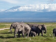 Elephants grazing in Amboseli swamps, north of Mount Kilimanjaro
Amboseli was home to Echo, perhaps the most researched elephant in the world, and the subject of many books and documentaries, followed for almost four decades by American conservationist Dr Cynthia Moss. Echo died in 2009 when she was about 60 years old.
Amboseli National Park offers some of the best opportunities to see African wildlife because the vegetation is sparse due to the long, dry months. The protected area is home to African bush elephant, Cape buffalo, impala, lion, cheetah, spotted hyena, Masai giraffe, Grant's zebra, and blue wildebeest. A host of large and small birds occur too.
The park has several rules to protect the wildlife: Never leave the vehicle, except at designated spots; do not harass the animals in any way; always keep to the tracks; no off-road driving; and always give the animals the right of way. The roads in Amboseli have a loose surface of volcanic soil that is dusty in the dry season and impassable in the wet season.
Arabuko Sokoke National Park
 The Arabuko Sokoke Forest Reserve is located on the coast of Kenya,
110 km north of Mombasa and is protected as a national Forest Reserve.
The Arabuko Sokoke National Park,
situated at the north-western edge of the Arabuko Sokoke Forest
Reserve, is only a few square kilometres in size and constitutes only a
small portion of the latter.
The Arabuko Sokoke Forest Reserve is located on the coast of Kenya,
110 km north of Mombasa and is protected as a national Forest Reserve.
The Arabuko Sokoke National Park,
situated at the north-western edge of the Arabuko Sokoke Forest
Reserve, is only a few square kilometres in size and constitutes only a
small portion of the latter.
 Protection
The
National Park was gazetted only in the late 1980s and in fact straddles
the Forest Reserve boundary, with about 50% lying outside the boundary.
This outer section actually lies outside an electric elephant fence
installed in 2006/7 and is now fully inhabited by local communities to
the extent that there is no sign on the ground to show where the
National Park begins or ends. The National Park doesn't add any
particular protection to the forest which is the largest fragment of
coastal forest (420 square km) left in East Africa.
The Forest Reserve, on the other hand, is jointly managed by the Kenya Forest Service, Kenya Wildlife Service, National Museums of Kenya and the Kenya Forest Research Institute and is one of the better protected forests in Kenya. The forest was first protected as a Crown Forest in 1943, and was gazetted in the 1960s. The forest is threatened by the desire for land by local people. Several national and international conservation organisations are working with the Kenya Wildlife Service to protect the park.
Wildlife
.jpg) The Arabuko Sokoke Forest is an area of high endemism,
containing endemic mammals, birds and plants. It contains three forest
types, mixed forest, Brachystegia and Cynometra, each of which protects different communities of plants and animals.
The Arabuko Sokoke Forest is an area of high endemism,
containing endemic mammals, birds and plants. It contains three forest
types, mixed forest, Brachystegia and Cynometra, each of which protects different communities of plants and animals.
_(14101276386).jpg)
It
protects many endemic and near endemic species. The Clarke's weaver is
completely endemic to the forest, while the eponymous Tanzania. The park
adjoins Mida Creek, a mangrove forest that is an important
shorebird wintering ground, protecting species such as the Terek
sandpiper and the crab plover.
_with_a_spider.jpg)
 The endearing golden-rumped elephant shrew, an endemic elephant shrew
the size of a rabbit, is the most noticeable of the park's endemic
mammals; the Sokoke bushy-tailed mongoose and Aders's duiker (found only
here and in Zanzibar) are more elusive. The forest also has savannah
elephants, African civets, as well as sokokes, baboons and vervet
monkeys. The park is also recognised as an outstanding centre of
amphibian diversity.
The endearing golden-rumped elephant shrew, an endemic elephant shrew
the size of a rabbit, is the most noticeable of the park's endemic
mammals; the Sokoke bushy-tailed mongoose and Aders's duiker (found only
here and in Zanzibar) are more elusive. The forest also has savannah
elephants, African civets, as well as sokokes, baboons and vervet
monkeys. The park is also recognised as an outstanding centre of
amphibian diversity.
Central Island National Park
Central Island, also known as Crocodile Island, is a volcanic island located in the middle of Lake Turkana in Kenya. It is also the location of Central Island National Park, which is governed by the Kenya Wildlife Service.<script data-ad-client="ca-pub-7190135829801849" async src="https://pagead2.googlesyndication.com/pagead/js/adsbygoogle.js"></script>
The Chyulu Hills is a mountain range in Makueni County, South Eastern Kenya. It forms a 100 kilometre long volcanic field in elongated NW-SE direction. Its highest peak is 2188 metres high.
The
park has a wide range of wild animals including the African bush
elephant, lion, African leopard, cheetah, eastern black rhinoceros,
southern white rhinoceros, Grévy's zebra, hippopotamus.
Meru
was one of the two areas in which conservationists George Adamson and
Joy Adamson raised Elsa the Lioness made famous in the best selling book
and award winning movie Born Free. Elsa the Lioness is buried in this park and part of Joy's ashes were scattered on her gravesite.
History
Between the years 2000 and 2005, the Kenya Wildlife Service, helped by the International Fund for Animal Welfare (IFAW), restored Meru National Park from near ruin to one of the most promising tourist destinations in Eastern Africa, solving the parks poaching problem. IFAW donated $1.25 million to this major restoration project, and with this money aided in improving the basic infrastructure and provided essential equipment and vehicles for law enforcement activities.Since 2005, the protected area is considered part of a Lion Conservation Unit.
Attractions
Aside from the scenery and wildlife, tourist attractions include the once home of George and Joy Adamson, Adamson's Falls, the burial sites of Joy Adamson and Elsa the Lioness, views of Mount Kenya, and the Tana River.Mombasa Marine Park
Mombasa Marine National Park and Reserve is a marine park and national reserve in Mombasa, Kenya. The park is 10 km² (2,500 acres) while the reserve is 200 km² (49,400 acres).
The Marine park is characterized by warm tropical conditions varying at the surface between 25°C and 31°C during the year, stable salinity regimes and moderate nutrient levels. It
is located on the coast near tourist areas and is a popular beach
because of the snorkeling and diving. It is the most heavily visited of
Kenya's marine parks. It has coral reefs in its waters.
It
is located on the coast near tourist areas and is a popular beach
because of the snorkeling and diving. It is the most heavily visited of
Kenya's marine parks. It has coral reefs in its waters.
It was established as a Marine Park in 1986, and encloses part of the lagoon, back reef and reef crest habitats of the Bamburi-Nyali fringing reef.
Mount Elgon National Park
Elgon's slopes support a rich variety of vegetation ranging from montane forest to high open moorland studded with the giant lobelia and groundsel plants.The vegetation varies with altitude. The mountain slopes are covered with olive Olea hochstetteri and Aningueria adolfi-friedericiiwet montane forest. At higher altitudes, this changes to olive and Podocarpus gracilior forest, and then a Podocarpus and bamboo Arundinaria alpina zone. Higher still is a Hagenia abyssinica zone and then moorland with heaths Erica arborea and Philippia trimera, tussock grasses such as Agrostis gracilifolia and Festuca pilgeri, herbs such as Alchemilla, Helichrysum, Lobelia, and the giant groundselsSenecio barbatipes and Senecio elgonensis.
The botanical diversity of the park includes giant podocarpus, juniper and Elgon olive trees cedar Juniperus procera, pillarwoodCassipourea malosana, elder Sambucus adnata, pure stands of Podocarpus gracilior and many orchids.
Of the 400 species recorded for the area the following are of particular note as they only occur in high altitude broad-leaf montane forest: Ardisiandra wettsteinii, Carduus afromontanus, Echinops hoehnelii, Ranunculus keniensis (previously thought to be endemic to Mount Kenya), and Romulea keniensis.Wildlife
Mammals
Elephants and buffalo can be found on the lower slopes. The park is also home to a variety of small antelope and duiker, as well forest monkeys, including the black-and-white colobus and blue monkey. red-tailed monkey have been reported after being thought to be locally extinct. Both leopard and hyena existed there in the late 1990s.
Birds
Mount Elgon is home to at least 144 bird species. Of particular interest are Jackson's francolin, the eastern bronze-naped pigeon, Hartlaub's turaco, the Tacazze sunbird and the endangered lammergeier, due to their restricted range.
Invertebrates
Maathai's longleg, an endangered dragonfly was discovered here in 2005 and named after Nobel Prize winner Wangari Maathai.
Half of Uganda's butterfly species have been reported in Mt. Elgon.
Conservation management
Prior to colonial administration, the land around Mount Elgon was managed based on indigenous power structures and rules, which forbade certain excessive utilization of natural resources on the communally owned upper elevations of the mountain. Demand for these resources was met sustainably because the human population density in the surrounding area was many times smaller than it is today.- <script data-ad-client="ca-pub-7190135829801849" async src="https://pagead2.googlesyndication.com/pagead/js/adsbygoogle.js"></script>
-
Uganda
The Uganda Protectorate administration gazetted its side of Mount Elgon a Forest Reserve, managed by the Forestry Department, in 1929. In 1937, the boundary survey was completed but parcels were repeatedly degazetted to provide land for local residents. In 1940, the area became the Mount Elgon Crown Forest and in 1951 a Central Forest Reserve.
In 1983, the Ugandan government opened up a 6,000-hectare (15,000-acre) of the reserve for settlement by the encroaching Benet-Ndorobo group. An additional 1,500 hectares (3,700 acres) were settled illegally. The area legally remained a part of the reserve until 2002 when it was officially degazetted.Management of the park disintegrated during the civil wars. In January 1994, the reserve was finally converted into a national park, although timber harvesting continued in some areas.
Attractions
Together with the fauna and flora, the park has a variety of scenery; this includes cliffs, caves, waterfalls, gorges, mesas, calderas, hot springs, and the mountain peaks. The most popular areas are the four explorable, vast caves where frequent night visitors such as elephants and buffaloes come to lick the natural salt found on the cave walls. Kitum cave, with overhanging crystalline walls, enters 200 m into the side of Mt. Elgon.
At the Endebess Bluff there a panoramic view of the areas' escarpments, gorges, mesas, and rivers. The highest peak of Mt. Elgon on the Kenya side, Koitoboss, measures 13,852 ft (4,155 m), and is easily reached by hikers in about two hours from the road's end. Activities include
Self-guided walking trails
Hiking to Endebess Bluff and Koitoboss Peak
Primate and bird watching
Cave explorations
Camping photography
Mount Elgon Caves
Recent
studies have shown that elephants and other mammals are major
contributors to the development of these unique natural phenomena. The
animals frequently visit at night to 'mine' the natural salt by licking
it from the cave walls. The caves are mapped and Kitum, Chepnyali, and Mackingeny can be explored by visitors to the park
Other attractions
Other attractions include ancient cave paintings near the trailhead at Budadiri, and hot springs in the former volcano's crater which bubble at temperatures of up to 48 °C.Mount Kenya National Park

- Mount Kenya National Park was established in 1949 to protect Mount
Kenya, the wildlife and surrounding environment, which forms a habitat
for wild animals, as well as acting as an area for the catchment of
water, to supply Kenya's water.
The Government of Kenya had four reasons for creating a national park on and around Mount Kenya. These were the importance of tourism for the local and national economies, to preserve an area of great scenic beauty, to conserve the biodiversity within the park, and to preserve the water-catchment for the surrounding area.
Initially, it was a forest reserve, before being announced as a national park. Currently, the national park is encircled by the forest reserve.In April 1978, the area was designated a UNESCO Biosphere Reserve.Combined, the national park and forest reserve became a UNESCO World Heritage Site in 1997.
Area
The national park has an area of 715 square kilometres (276 sq mi), most of which is above the 3,000-metre (9,800 ft) contour line.The forest reserve has an area of 705 square kilometres (272 sq mi). Combined, this makes the area of the UNESCO World Heritage Site 1,420 square kilometres (548 sq mi).
Volcanicsediment in the surrounding region's soil and the huge volume of fresh water coming down the slopes makes the area particularly favorable for agriculture.Fauna
A small portion of this park's borders near heavy populations have electrified fences to keep the elephants out of the surrounding farmland. At lower altitudes, black-and-white colobus and other monkeys, and Cape buffaloes are prevalent. In 1993, a huge male lion weighing 272 kg (600 pounds) was shot near the mountain.National Park -
Mount Longonot is a stratovolcano located southeast of
Lake Naivasha in the Great Rift Valley of Kenya, Africa. It is thought
to have last erupted in the 1860s. Its name is derived from the Maasai
word Oloonong'ot, meaning "mountains of many spurs" or "steep ridges".
Mount Longonot is protected by Kenya Wildlife Service as part of Mount Longonot National Park. A 3.1 km trail runs from the park entrance up to the crater rim, and continues in a 7.2 km loop encircling the crater. The whole tour (gate-around the rim-gate) of 13.5 km takes about 4–5 hours allowing for necessary rest breaks - parts of the trail are heavily eroded and very steep. The gate elevation is around 2150 m and the peak at 2780 m but following the jagged rim involves substantially more than the 630 m vertical difference.
Flora and fauna
A forest of small trees covers the crater floor, and small steam vents are found spaced around the walls of the crater. The mountain is home to various species of wildlife, notably plains zebra, giraffe, Thomson's gazelle, buffaloes and hartebeest. African leopards have also been reported but are extremely difficult to spot.
Mount Longonot is 60 kilometres northwest of Nairobi and may be reached from there by a tarmac road. A nearby town is also named Longonot. The Longonot satellite earth station is located south of the mountain.
Geology
Longonot is a stratovolcano which contains a large 8 x 12 km caldera formed by vast eruptions of trachytic lava some 21,000 years ago. The current summit cone was developed within the earlier caldera. This cone itself is capped by a 1.8 km crater. The Mountain has several parasitic cones and effusive lava eruptions occur on the flanks and within the caldera floor.Periodic geodetic activity recorded at Longonot in 2004–2006 demonstrated the presence of active magmatic systems beneath this volcano.
As of 2018, geothermal projects struggle to explore the potential.
Notable Events
On March 21, 2009 Brush Fires burned up the side of the mountain and descended into the crater, trapping wildlife and feeding on drought ravaged brush.
 Longonot Earth Station 2010
Nairobi National Park
- Still, despite its proximity to civilisation and relative small size for an African national park, Nairobi National Park boasts a large and varied wildlife population. Migrating herbivores gather in the park during the dry season, and it is one of Kenya's most successful rhinoceros sanctuaries.
 Nairobi National Park
is a national park in Kenya. Established in 1946, the national park was
Kenya's first. It is located approximately 7 kilometres (4 mi) south of
the centre of Nairobi, Kenya's capital city,with an electric fence
separating the park's wildlife from the metropolis.
Nairobi's skyscrapers can be seen from the park. The proximity of urban
and natural environments has caused conflicts between the animals and
local people and threatens animals' migration routes.
Nairobi National Park
is a national park in Kenya. Established in 1946, the national park was
Kenya's first. It is located approximately 7 kilometres (4 mi) south of
the centre of Nairobi, Kenya's capital city,with an electric fence
separating the park's wildlife from the metropolis.
Nairobi's skyscrapers can be seen from the park. The proximity of urban
and natural environments has caused conflicts between the animals and
local people and threatens animals' migration routes.
Colonists arrived in the area where the park is in the late 19th century. At this time, the Athi plains east and south of what is today Nairobi had plentiful wildlife. Nomadic Maasai lived and herded their cattle among the wildlife. Kikuyu people farmed the forested highlands above Nairobi. As Nairobi grew—it had 14,000 residents by 1910—conflicts between humans and animals increased. Residents of the city carried guns at night to protect against lions. People complained that giraffes and zebras walked on and ruined their flower beds. Animals were gradually confined to the expansive plains to the west and south of Nairobi, and the colonial government set this area aside as a game reserve. Settlers from Nairobi including Isak Dinesen, author of Out of Africa, rode horses among gazelles, impala, and zebras in this reserve.
History
The conservationist Mervyn Cowie was born in Nairobi. Returning to Kenya after a nine-year absence in 1932, he was alarmed to see that the amount of game animals on the Athi plains had dwindled. Expanding farms and livestock had taken the place of the game. He later recalled this place as a paradise that was quickly disappearing. At this time, the area that would later become Nairobi National Park was part of the Southern Game Reserve. Hunting was not permitted in the reserve, but nearly every other activity, including cattle grazing, dumping, and even bombing by the Royal Air Force was allowed. Cowie started to campaign for the establishment of a national park system in Kenya. The government formed a committee to examine the matter.
Officially opened in 1946, Nairobi National Park was the first national park established in Kenya. Maasai pastoralists were removed from their lands when the park was created. Cowie was named as director of Nairobi National Park and held this position until 1966. In 1989, Kenyan President Daniel arap Moi burned twelve tons of ivory on a site within the park. This event improved Kenya's conservation and wildlife protection image.
Geography
The park covers an area of 117.21 km2 (45.26 sq mi) and is small in comparison to most of Africa's national parks. The park's altitude ranges between 1,533 and 1,760 m (5,030 and 5,774 ft).It has a dry climate. The park is the only protected part of the Athi-Kapiti ecosystem, making up less than 10% of this ecosystem.The park has a diverse range of habitats and species.
The park is located about 7 km (4.3 mi) from the Nairobi's centre. There is electric fencing around the park's northern, eastern, and western boundaries. Its southern boundary is formed by the Mbagathi River. This boundary is not fenced and is open to the Kitengela Conservation Area (located immediately south of the park) and the Athi-Kapiti plains. There is considerable movement of large ungulate species across this boundary.
The fence that separates the park from the city runs along a highway leaving the airport, this is one fact many Kenyans are proud of – this park is the only natural safari park that has a city scape background that can be seen from almost any part of the park, as seen in the picture below of the giraffe and the sky scrapers.
Flora
The park's predominant environment is open grass plain with scattered Acacia bushes. The western uplands of the park have highland dry forest with stands of Olea africana, Croton dichogamus, Brachylaena hutchinsii, and Calodendrum. The lower slopes of these areas are grassland. Themeda, cypress, Digitaria, and Cynodon species are found in these grassland areas. There are also scattered yellow-barked Acacia xanthophloea. There is a riverine forest along the permanent river in the south of the park. There are areas of broken bush and deep rocky valleys and gorges within the park. The species in the valleys are predominantly Acacia and Euphorbia candelabrum. Other tree species include Apodytes dimidiata, Canthium schimperiana, Elaeodendron buchananii, Ficus eriocarpa, Aspilia mossambicensis, Rhus natalensis, and Newtonia species. Several plants that grow on the rocky hillsides are unique to the Nairobi area. These species include Euphorbia brevitorta, Drimia calcarata, and Murdannia clarkeana.
Fauna
The park has a large and diverse wildlife population. Species found in the park include Cape buffalo, baboon, eastern black rhino, gazelle, Grant's zebra, cheetah, Coke's hartebeest, hippopotamus, African leopard, lion, eland, impala, Masai giraffe, ostrich, vultures and waterbuck.
A Masai giraffe in Nairobi National Park.
Herbivores, including wildebeest and zebra, use the Kitengela conservation area and migration corridor to the south of the park to reach the Athi-Kapiti plains. They disperse over the plains in the wet season and return to the park in the dry season.The concentration of wildlife in the park is greatest in the dry season, when areas outside the park have dried up. Small dams built along the Mbagathi River give the park more water resources than these outside areas.They attract water dependent herbivores during the dry season. The park is the northern limit for wildlife migrations in the dry season. The park has a high diversity of bird species, with up to 500 permanent and migratory species in the park.Dams have created a man-made habitat for birds and aquatic species.
 The David Sheldrick Trust runs a sanctuary in the park that hand-rears orphaned elephant and rhinoceros calves, and later releases them back into secure sanctuaries. Orphaned and sick animals are brought to the sanctuary from all over Kenya. The sanctuary is located close to the park's main entrance. It was opened in 1963. It was set up by Daphne Sheldrick after the death of her husband David Sheldrick, the anti-poaching warden of Tsavo National Park. Nairobi National Park is sometimes called Kifaru Ark, which means "Rhinoceros Sanctuary". It is one of Kenya's most successful rhinoceros sanctuaries, and it is one of only a few parks where visitors can be certain of seeing a black rhinoceros in its natural habitat.A Rüppell's vulture in the park
Conservation
 Mervyn Cowie oversaw the development of several of Kenya's national parks and designed them with human visitors in mind. This emphasis helped to make tourism Kenya's primary industry. However, it exacerbated problems between the human population and wildlife. Farmers living next to the parks did not have input into the establishment of the parks. Locals received very little benefit from the game animals. Livestock is threatened by lions, and some landowners think that Kenya's wildlife is not good for them. In 1948, 188,976 people lived in Nairobi, and by 1997 the city's population had grown to 1.5 million. The park is under pressure from the city's growing population and need for farmland. People live right next to the park's boundaries, which creates human-animal conflicts. The human population also creates pollution and garbage. Effluent and industrial waste from factories located along the park's northern boundary contaminate the park's surface and ground water systems.A giraffe in Nairobi National Park, with Nairobi's skyline in the background.
Treaties with the Maasai in 1904 and 1911 forced them to give up all of their northern grazing lands on the Laikipia escarpment near Mount Kenya. Some of the people that lost land there were resettled in the Kitengela area. The Maasai's pastoral life did not create any conflicts with the wildlife. Today the Kitengela's former Maasai group-ranches have been privatized and some of the land has been sold to farmers. Houses, cultivated plots, schools, shops, and bars are found on the Kitengela plains. Some of the park's revenues have been used for community projects in order for the people living on the Kitengela to benefit from the presence of the national park. Many Maasai landowners have formed the Kitengela Landowners Association, which works with the Kenyan Wildlife Service to both protect the wildlife and find benefits for the locals.
The park and the Athi-Kapiti Plains are linked by the migrations of wild herbivore populations. The plains to the south of the park are important feeding areas during the wet season. Before the city was established, herds of animals followed the rains and moved across the plains from Mount Kilimanjaro to Mount Kenya, a migration as great as the migration that takes place on the Serengeti. However, as the city grew the park became the northernmost limit of the animal's migration. Migrating animals can reach their southern pastures by travelling through the part of the Athi plains called the Kitengela. This land is very important to their migration routes, but growth in the human population and the accompanying need for land threaten to cut off this traditional migration route from the park to land further south. The park's migratory species are also threatened by changing settlement patterns, fencing, and their closeness to Nairobi and other industrial towns. These activities fragment their ecosystems and occupy their habitat.
Since 2005, the protected area is considered a Lion Conservation Unit. -
Tourism and education
Nairobi National Park is the main tourist attraction for visitors to Nairobi. Visitor attractions include the park's diverse bird species, cheetah, hyena, leopard, and lion. Other attractions are the wildebeest and zebra migrations in July and August, the Ivory Burning Site Monument, and the Nairobi Safari Walk and animal orphanage. Inhabitants of Nairobi visit the park and thousands of Kenyan children on school field trips visit the park each week.
The park's Wildlife Conservation Education Centre has lectures and video shows about wildlife and guided tours of the park and animal orphanage. These tours are primarily, but not exclusively, to educate schools and local communities. There has been criticism about animals' housing, and they now have more spacious housing in a more natural environment. The Kenya Wildlife Service has created a Safari Walk that highlights the variety of plants and animals that are in Kenya, and how they affect Kenya's population. - Donyo Sabuk National Park
-
Ol Donyo Sabuk (in Kikamba, Kiima Kya Mboo/ Kyanzavi)
is a mountain and an adjacent small town near Thika Kenya. The town is
located in Kyanzavi Division, Machakos County. The peak, height 2,145
metres (7,037 ft),
was named by Maasai pastoralists, meaning big mountain. The Kikamba name, Kiima kya mboo, means Buffalo Hill or Mountain. Buffalo is called Nyati or "Mboo" in Swahili, . The town stands at the edge of Machakos County.
Lord William Northrup McMillan was the first white man to settle here, and everything else that has happened since is largely attributed to him (see below: Lord William Northrop McMillan). The town is quite dusty, due to deforestation and loose ground cover, compounded by occasional rainfall. However, the area is adorned with lots of untamed beauty.
The town is located about 18.5 km (11.5 mi) east-southeast of Thika, along the Thika-Garissa road (A3 road). Driving on Garissa Road from Thika town, there are pineapple plantations on both sides, accentuated by little pockets of blooming eucalyptus. About 18 kilometres (11 mi) east of Thika, there is a junction going south, with Kenya Wildlife Service markings. It will be a 3-kilometre (1.9 mi) drive from here to the famous Fourteen Falls, described as one of Kenya's most spectacular landmarks. By the river is St. Johns Kilimambogo Teachers College, and Immaculate Heart of Mary Mission hospital. Donyo Sabuk town is a kilometre (half-mile) away from Fourteen Falls, just across the Athi River, with a junction leading to the game park, and the other to the great house of Donyo Sabuk.
Down past the 2,145 m (7,037-foot) mountain base sits Donyo Sabuk town, a town that has retained many things that Lord Macmillan bequeathed the area. Here, partying goes on well into the night, and there are a number of "boys’ bands", where the box guitar is still in vogue. This musical town is the hometown of the late Kamba musician Kakai Kilonzo, late legendary Sila of Kilunda fame, and the still-active Gä'thika boys band.
Near the peak is the grave of Lord Macmillan, his wife and their dog. Also, there is an extra grave of one Louise, who started working for the Macmillan's when she was age 13 until her death.
In what was once one of the biggest ranches in Kenya, there are five towns inside the former Juja Ranch. The rural area is a multi-ethnic community in farms owned by people who were former squatters and his farm labourers. The mountain peak is inside a game park, and the rest is partially owned by the Kenyatta familySir William Northrup McMillan
William Northrup McMillan was an American multimillionaire and philanthropist who owned substantial farms in British East Africa. In 1905 he acquired a 99 year lease on 4,000 ha (10,000 acres) 32 km (20 mi) north of the city which eventually became Juja Farm. In 1905 he constructed the five bedroom Juja House on the property. The main house was followed by a three bedroom manager's bungalow, a two bedroom bungalow called "Lucie's bolthole," and three other bungalows housing the post and telegraph office, and rooms for chauffeurs and gardeners. The homes were fitted with electricity and running water, and a sewage system In later years, Juja Farm would become a popular location for film crews.
Ol Donyo Sabuk National Park
The name of this park established in 1967, Ol Donyo Sabuk, means large mountain in Maasai. It is situated 65 km (40 mi) north of Nairobi and has an excellent and clear view of Nairobi and other lowland areas. Wildlife species that can be spotted here include buffalo, colobus monkeys, baboons, bushbuck, impala, duiker, and abundant birdlife.
Ol Donyo Sabuk National Park is a common one-day trip out of Nairobi,only 65 km (40 mi) away. The mountain is the highest peak in the park, covering 20.7 km2 (8.0 sq mi). It is particularly attractive for hikers or families wanting some freedom and exercise, outside their vehicles. One approach to the park is via the Fourteen Falls on the Athi River. The park's attraction is its beauty and views of both Mt. Kenya and Mt. Kilimanjaro. It teems with game including baboon, colobus, bushbuck, impala, duiker and many birds. While the name "Ol Donyo Sabuk" is Maasai for 'large mountain', the word Sabuk was mistakenly thought by many writers to mean "buffalo" whereas in fact Maasai call buffalo Olosowan. Today, some 250 buffalos roam the slopes.Kikuyu traditionalists also call the mountain by Kea-Njahe, known as the 'Mountain of the Big Rain', one of Ngai's lesser homes.
The solitary mountain rises to 2,145 m (7,037 ft) from an otherwise flat area.The steep ascent requires a 4WD (4×4) vehicle. Near the summit lie the graves of Sir William Northrup McMillan (1872–1925) and his wife Lady Lucie.
Tom Mboya
It was here in 1930, that one of Kenya's most colourful politicians, Tom Mboya, was born and brought up, when his father worked in the farm as a labourer. Though the setting is not in a valley, this circuit comprised a prime chip of the famed Happy Valley set. Tom Mboya attended Kilimambogo Primary School, a Catholic Missionary Sponsored institution, within the larger St. Johns Kilimambogo Teachers College.
Kilimambogo Region
This is a Nairobi metropolitan region, ranging from Kwa Mwaura and Munyu Mweu area, in Matungulu North Ward Machakos County to Gatuanyaga near Thika Town Kiambu County and back through Juja Farm to Koma. Areas within the region have local names, Kyanzavi being the popular name for the Ukamba region. The area is full of culture, with almost all Kenyan tribes and cultures represented.
Wanjiku Kahore (Maendeleo)
It was in 1960, when she arrived in the ranch, from Kinyui. She had bundled up her few possessions, which included a then-coveted linen business, making a hallmark grand entry, and influencing what would turn Ol-Donyo into a famous trading centre. Given its existing large labour population, she saw enormous business opportunity that had characterised the town until the end of the 70
s. Locals honoured her by naming the adjacent trading centre after her. But after the fall of Muka Mukuu farmer's cooperative, the area was dismayed. The Ol-Donyo Sabuk status is a direct portrayal of the locals' state of financial affairs.wanjiku was the owner of Masaku trust land including Tala, Kangundo, Kawethei, Kakuyuni and many others. It was confirmed in succession cause No: 332 of 2008 in the high court of kenya,in the same kenya Gazette notice No: 1705 of 2007.She was also a prominent businesswoman in the world.
The McMillan Castle
Covering a ground enough for three basketball pitches, the villagers have spent more than a century wondering why a couple that had no children put up such a huge dwelling place. So large is the building that Lord Macmillan and his wife would spend one year in one wing of the house, then migrate to the other in the second half of the year. The locals are yet to figure out how they can benefit from such an obvious tourist attraction site.
Further east of Ol-Donyo, the building that was McMillan's home, a fort by any definition, sits in splendour. More than three-quarters of the house is under key and lock. A part of it houses the Muka Mukuu Farmer's Co-operative Society, Ltd. a farmer's cooperative. The land around the home is currently used for the production of pineapples.
Club House (Kilavu)
The early notorieties of the ranch captured the imagination of many people during the First World War, when the castle served as a military hospital for British officers. The wild parties held in the castle, where the notorious colonial maverick Colonel Ewart Grogan reputedly led the wine-tossing and supervised wife-sharing orgies, only spiced the sideshows that attracted international media. Hence the castle was baptised "Kilavu" by the locals, meaning Club house in Kamba. ClubHouse
Fourteen Falls
 The Fourteen Falls area is protected and equipped with a picnic site. It has historical and religious importance both to the residents and Asian immigrants. The Asians use the site for recreation and spiritual rites, disposing of cremated ash in the river in the belief that it will go all the way to India through the Indian Ocean, hence acting as a shrine. Others come for recreation, retaining the Happy Valley theme that was first introduced by Lord McMillan. Like Lord McMillan, the adjacent community, some of whom are descendants of the people the adventurer brought here, still farm the land. Fourteen Falls is located just a little bit away from Thika town.The falls are geographically situated at an altitude of approximately 1400 metres above sea level.The Fourteen Falls
Ruma National Park
Ruma National Park is the only terrestrial park in Kenya's Nyanza Province. Dubbed the "Last Retreat of the Roan Antelope", the park protects the only indigenous population of rare roan antelopes within Kenya. At present, the population is on the verge of extinction with individual populations numbering approximately 40. The park was established in 1966 as Lambwe Valley Game Reserve. It was later renamed “Ruma” after one of Kenya’s most powerful wizard, the much feared Gor Mahia who lived around the park (affiliated to Gor Mahia F.C.). The park is located in the vast Lambwe Valley.Wildlife
Game species range from African leopards (Panthera pardus pardus), roan antelopes (Hippotragus equinus), eastern black rhinoceros (Diceros bicornis michaeli), Rothschild's giraffes (Giraffa camelopardalis rothschildi), oribis (Ourebia ourebi), cape buffalos, Lelwel hartebeests (Alcelaphus buselaphus lelwel), olive baboons, Bohor reedbucks (Redunca redunca), hyenas, servals (Leptailurus serval), topis (Damaliscus korrigum), honey badgers (Mellivora capensis), bushpigs (Potamochoerus larvatus) and vervet monkeys among others.
Over 400 species of birds have been recorded in the park, making it an Important Bird Area. The rare intra-African migrant, the blue swallow (Hirundo atrocaerulea) is one such avian species.
Tsavo East National Park
Tsavo West National Park is located in the Coast Province of Kenya. The park covers an area of 9,065 square kilometres. The A109 road Nairobi-Mombasa and a railway divides it from the adjoining Tsavo East National Park. Together with adjoining ranches and protected areas, they comprise the Tsavo Conservation Area. Tsavo West is a more popular destination[on account of its magnificent scenery, Mzima Springs, rich and varied wildlife, good road system, rhino reserve, rock climbing potential and guided walks along the Tsavo River. The park is operated by Kenya Wildlife Service.Archaeology and history
Although a few Early Stone Age and Middle Stone Age archaeological sites are recorded from ground surface finds in Tsavo, there is much evidence for thriving Late Stone Age economy from 6,000 to 1,300 years ago. Research has shown that Late Stone Age archaeological sites are found close to the Galana River in high numbers. The inhabitants of these sites hunted wild animals, fished and kept domesticated animals. Because of the sparse availability of water away from the Galana River, human settlement in Tsavo focused on the riparian areas and in rockshelters as one moves west.
Swahili merchants traded with the inhabitants of Tsavo for ivory, catskins, and probably slaves as early as 700 AD (and probably earlier). There is no evidence for direct Swahili "colonization" of Tsavo. Instead, trade was probably accomplished by moving goods to and from the Swahili Coast via extended kin-networks. Trade goods such as cowry shells and beads have been recovered from archaeological sites dating to the early Swahili period.
19th-century British and German explorers document people we now refer to as Orma and Waata during their travels through the "nyika," and generally viewed them as hostile toward their interests. Beginning in the late 19th century, the British began to colonise the interior of Kenya and built the Uganda Railway through Tsavo in 1898. The construction of the railway was noted for the killings of a number of construction workers in 1898, during the building of a bridge across the Tsavo River. Hunting mainly at night, a pair of maneless male lions stalked and killed at least 28 Indian and African workers – although some accounts put the number of victims as high as 135. The lions, dubbed "the Maneaters of Tsavo," were eventually shot and killed by the bridge construction supervisor, Lt.-Col. John Henry Patterson. The skins and skulls are now displayed in the Field Museum of Natural History in Chicago.
Tsavo remained the homeland for Orma and Maasai pastoralists and Waata hunter-gatherers until 1948, when it was gazetted a national park. At that time, the indigenous populations were relocated to Voi and Mtito Andei as well as other locations within the nearby Taita Hills. Following Kenyan independence in 1963, hunting was banned in the park and management of Tsavo was turned over to the authority that eventually became the Kenya Wildlife Service. Tsavo currently attracts photo-tourists from all over the world interested in experiencing the vastness of the wilderness and incredible terrain.Rock climbing
In 1978 Bill Woodley, then the warden of Tsavo West, invited the Mountain Club of Kenya (MCK) to explore the cliffs in the park. The setting for climbers is superb with elephant roaming the plains below the cliffs and eagles, vultures and falcons circling on thermals around the crags with Kilimanjaro frequently visible on a clear day. The rock-climbing is some of the best in Kenya, solid gneiss walls are often covered in holds and free of vegetation. Cracks and corners abound, but tend to be more vegetated. The most impressive piece of rock, the 300m high east face of Kichwa Tembo, attracted the first explorers and resulted in the ascent of Great Tsavo Chimney. Mastodon took three visits before it was completed. A more recent route, Ivory Tower on Elephant Rocks, ranks with the best and hardest bush climb in Kenya. Generally pegs need not be carried. Unless climbing in the shade, an early start is advisable as it often gets very hot on clear days.
Below Kitchwa Tembo cliffs at dawn.
The permit the MCK has to climb here, and to camp by the Tsavo River, is a special privilege and every effort must be made not to jeopardise this situation by careless actions. Other climbers should initially contact the MCK if wishing to climb here.
Details of climbs and access procedures: Rock Climbing Guide to Kichwa Tembo
Wildlife
Lake in the Tsavo West National Park
 Tsavo
West National Park has a variety of wildlife, such as eastern black
rhinoceros, hippopotamus, Cape buffalo, elephant, leopard and lion.
There are also other smaller animals that can be spotted in the park,
such as the bushbaby, hartebeest, lesser kudu and Masai giraffe.
Tsavo
West National Park has a variety of wildlife, such as eastern black
rhinoceros, hippopotamus, Cape buffalo, elephant, leopard and lion.
There are also other smaller animals that can be spotted in the park,
such as the bushbaby, hartebeest, lesser kudu and Masai giraffe.
- Tsavo West National ParkTsavo West National Park is located in the Coast Province of Kenya. The park covers an area of 9,065 square kilometres. The A109 roadNairobi-Mombasa and a railway divides it from the adjoining Tsavo East National Park. Together with adjoining ranches and protected areas, they comprise the Tsavo Conservation Area. Tsavo West is a more popular destinationon account of its magnificent scenery, Mzima Springs, rich and varied wildlife, good road system, rhino reserve, rock climbing potential and guided walks along the Tsavo River. The park is operated by Kenya Wildlife
Tsavo East National Park is one of the oldest and largest parks in Kenya at 13,747 square kilometres. Situated in a semi-arid area previously known as the Taru Desert it opened in April 1948, and is located near the town of Voi in the Taita-Taveta County of the former Coast Province. The park is divided into east and west sections by the A109 road and a railway. Named for the Tsavo River, which flows west to east through the national park, it borders the Chyulu Hills National Park, and the Mkomazi Game Watamu Marine National Park
Water temperature varies from 20 degrees Celsius (June to November) to 30 degrees Celsius (December to May). The park was designated as a biosphere reserve in 1979. Watamu Marine National Park and Reserve
is located in Kenya. Established in 1968, it was one of Kenya's first
marine parks. It is located about 90 miles (140 km) north of Mombasa,
Kenya's second largest city. Its coral gardens are merely 300 metres
(980 ft) from the shore and are home to approximately 600 species of
fish, 110 species of stony coral and countless invertebrates,
crustaceans and molluscs.
Watamu Marine National Park and Reserve
is located in Kenya. Established in 1968, it was one of Kenya's first
marine parks. It is located about 90 miles (140 km) north of Mombasa,
Kenya's second largest city. Its coral gardens are merely 300 metres
(980 ft) from the shore and are home to approximately 600 species of
fish, 110 species of stony coral and countless invertebrates,
crustaceans and molluscs.History
Watamu Marine National Park and Reserve was established in 1968 with Malindi Marine National Park and Reserve. They were established by the Kenyan government. Watamu Marine Park is now part of a UN recognised World Biosphere Reserve.
Wildlife
The park's coral reefs form the physical and biological backbone of the area. With over 150 species of hard and soft corals, such as brain corals, fan corals and sponges, it provides for abundant nutrients for fish. The main park has over 500 species of fish and the reserve over 1000. There are also whale sharks, manta rays, octopus and barracuda as some of the larger species in the park.
Watamu also has different species of turtles and a turtle watch program which has managed to secure the main park's beach as a 99% viable sea turtle nesting site for endangered sea turtles. This beach is patrolled and monitored vigorously. The turtles nesting in Watamu include the Green, Hawksbill and Olive Ridley turtles. The Olive Ridley species is rare but occasionally comes to the nesting site. Leatherback turtles do not nest in Watamu or Malindi but they pass by through the nearby waters during their migration.
Conservation
Bleaching of the water in Watamu Marine Park, a marine protected area (MPA), occurred between 1997 and 1998. This was the single most important impact on the sea water that caused high levels of mortality to the coral reefs in Malindi and Watamu. Usually recovery is variable and depends on the reefs but Watamu was slower than average in recovery. Surveys showed that urbanization and coastal development, especially from tourism and agricultural sectors, contributed to increased degradation of the marine environment in the area. Removal of forests and natural vegetation for agriculture, removal of mangroves for building and fuel, and fishing to meet the demands of a growing urban population, all contributed to increased threats on the marine ecosystems of the MPA. This ecosystem includes of coral reefs, mangrove forests and sea grass beds. Land-use plans had to be incorporated into the MPA management plan. The inclusion took into consideration issues of coastal destruction of habitats for marine species including marine turtles and shorebirds, as well as improved enforcement of existing land-use statutes.
In Watamu and Malindi parks, a local marine conservation organisation seeks to protect marine life, especially sea turtles, by the means of a direct payment method program. The program pays local fishermen to tag and release sea turtles caught while fishing. For every turtle release, the fishermen are compensated for their time, efforts and potential damage to fishing gear, thus providing an incentive for releasing the animals instead of killing them. After the fishermen release the turtles, they notify Watamu Turtle Watch (WTW) volunteers who rush to the landing site. The volunteers then have an opportunity to measure and examine the animals as well as place ID tags on them before they are returned to freedom. This program has benefited the research of turtle nesting habits. Also, the center administering the program provides turtle rehabilitation for sick turtles, and has an adopt-a-turtle program, and studys the socio-economics of fishing communities. Fishermen are also allowed to fish in the protected reserve as long as they only take out the species of fish allowed by the park and use traditional methods of fishing.
Credits:
some help from wikipedia.com- www.zimbermann'sideals.com


 It
is composed of more than a dozen craters and cones, three of
which are filled by small lakes. The two largest lakes partially fill
craters up to a kilometre wide and about 80 m deep, the floors of which
are near sea level. The highest point on the dominantly basaltic
island reaches 550 m, about 190 m above the lake surface. An
E-W-trending chain of small explosion craters cuts the eastern side of
the 3-km-wide island. Several small islands to the SE represent
partially submerged crater rims, and other cones and lava plugs lie
beneath the lake surface near the island.
The youngest Central Islands tuffs and lavas may be as young as Holocene
(Karson and Curtis, 1992). Fumarolic activity is concentrated along the
NE-to-SE rim of the central crater, and sprays of sulfur from the
fumaroles were observed by visitors in the 1930s. In 1974 intense
emission of molten sulfur and steam clouds were seen from the mainland.
It
is composed of more than a dozen craters and cones, three of
which are filled by small lakes. The two largest lakes partially fill
craters up to a kilometre wide and about 80 m deep, the floors of which
are near sea level. The highest point on the dominantly basaltic
island reaches 550 m, about 190 m above the lake surface. An
E-W-trending chain of small explosion craters cuts the eastern side of
the 3-km-wide island. Several small islands to the SE represent
partially submerged crater rims, and other cones and lava plugs lie
beneath the lake surface near the island.
The youngest Central Islands tuffs and lavas may be as young as Holocene
(Karson and Curtis, 1992). Fumarolic activity is concentrated along the
NE-to-SE rim of the central crater, and sprays of sulfur from the
fumaroles were observed by visitors in the 1930s. In 1974 intense
emission of molten sulfur and steam clouds were seen from the mainland.Chyulu Hills National Park
Geography
 The Chyulu Hills are located about 150 km east of the Kenya Rift.
The hills consists of several hundred small flows and cones.
Volcanism in the area started about 1.4 million years ago in the
northern parts of the hills, and over time the volcanism propagated
towards the southeast. These volcanoes are still
considered active, since their last two eruptions (Shaitani and Chainu)
occurred in 1856. Within the hills is the Leviathan Cave, one of the longest lava tubes in the world.
The Chyulu Hills are located about 150 km east of the Kenya Rift.
The hills consists of several hundred small flows and cones.
Volcanism in the area started about 1.4 million years ago in the
northern parts of the hills, and over time the volcanism propagated
towards the southeast. These volcanoes are still
considered active, since their last two eruptions (Shaitani and Chainu)
occurred in 1856. Within the hills is the Leviathan Cave, one of the longest lava tubes in the world.Kibwezi town is located 30 km northeast of the Chyulu Hills.
The Chyulu Hills do not have any permanent rivers, but rainfall on hills feeds the Tsavo and Galana rivers and Mzima Springs on the surrounding plains.
Ecology
Lower parts of the hills are composed of grassland and thicket, while
above roughly 1800 metres is dominated by montane forest. The forest
contains Neoboutonia macrocalyx, Tabernaemontana stapfiana, Prunus
africana, Strombosia scheffleri, Cassipourea malonsana, Olea capensis
and Ilex mitis. Some isolated parts are dominated by Erythrina
abyssinica. Lower parts of the forest are dominated either by Juniperus
procera or Commiphora baluensi.
Mammals found in the hills include eastern black rhinos, (Diceros bicornis michaeli), Cape buffaloes, bushbucks, elands, elephants, bushpigs, Masai giraffe, leopards, lions, mountain reedbucks, steinbok, wildebeest and Grant's zebras. Cheetahs are found at the plains of Chyulu Hills. Various snakes inhabit the hills, like black mamba, puff adder and rock python.
There are various bird species on the hills, with some endemic races. Bird species include: Francolinus shelleyi, Pogonocichla stellata, Zoothera gurneyi, Bradypterus cinnamomeus, Hieraaetus ayresii, Stephanoaetus coronatus, Polemaetus bellicosus and Cinnyricinclus femoralis.
There is wild khat growing on the hills, which is picked by local people. There is also some cultivation of khat around the hills. Khat from Chuylu hills is known as Chuylu, as opposed to Miraa, which is cultivated in the Meru County.
Conservation
The Chyulu Hills National Park comprises the eastern flank of the hills and is operated by the Kenya Wildlife Service. The park was formed in 1983. It forms a northwestern continuation of Tsavo West National Park. The western flank of the hills is covered by the West Chyulu Game Conservation owned by Maasai group ranches.Potential threats to the ecosystem include poaching, overgrazing by growing population of Maasai herders and scarcity of water.
Hell's Gate National Park
History
Hell's Gate National Park is named after a narrow break in the cliffs, once a tributary of a prehistoric lake that fed early humans in the Rift Valley.It received the name "Hell's Gate" by explorers Fisher and Thomson in 1883. In
the early 1900s, Mount Longonot erupted, and ash can still be felt
around Hell's Gate. The comprehensive Olkaria Geothermal Station,
the first of its kind in Africa, was established in 1981 and generates
geothermal power underneath Hell's Gate from the area's hot springs and
geysers. The park was officially established in 1984.
In
the early 1900s, Mount Longonot erupted, and ash can still be felt
around Hell's Gate. The comprehensive Olkaria Geothermal Station,
the first of its kind in Africa, was established in 1981 and generates
geothermal power underneath Hell's Gate from the area's hot springs and
geysers. The park was officially established in 1984.Two more geothermal stations were added after 2000: Olkaria II and Olkaria III.
Geography

Fischer's Tower
Wildlife
There is a wide variety of wildlife in the national park, though many
are few in number. Examples of little seen wildlife include lions,
leopards, and cheetahs.However, the park has historically been an
important home for the rare lammergeyer vultures.There are over 103
species of birds in the park, including vultures, Verreaux's eagles,
augur buzzard, and swifts. Hyraxes, African buffalo, zebra, eland,
hartebeest, Thomson's gazelle, hyena, and baboons are also common. The
park is also home to serval and small numbers of klipspringer antelope
and Chanler's mountain reedbuck.
Tourism
The park is popular due to its close proximity to Nairobi and lowered
park fees compared to other National Parks. Hiking, bicycling,
motorcycling and even camping are encouraged within the park, one of
only two Kenyan national parks where this is allowed.The Daily Nation
praised the mountain climbing in Hell's Gate as "thrilling." It also
recommended the Joy Adamson's Centre and boating on Lake Naivasha. A
Maasai Cultural Center provides education about the Maasai tribe's
culture and traditions.
The park is equipped with three basic campsites, camping is safe in the park even though there are no guns or fencing between you and wildlife. There are also several lodges around Naivasha Lake, popular among tourists for watersports, bird and game viewing in private ranches and walks along Crescent Island, Crater Lake, and Mt. Longonot.
The main setting of the 1994 film, The Lion King is heavily modeled after the park, where several lead crew members of the film went to the park to study and gain an appreciation of the environment for the film.
Kisite-Mpunguti Marine National Park
Kisite-Mpunguti Marine National Park
is situated on the southern coast of Kenya near Shimoni and south of
Wasini Island in Kwale District near the Tanzanian border. Kisite park
covers 11 square kilometres while Mpunguti reserve covers 28 square
kilometres.
The park covers an area with four small islands surrounded by coral
reef.
Marine
life is in abundance, including trigger fish, moray eels, angelfish,
butterfly fish, groupers, parrotfish, wrasses, scorpionfish, pufferfish,
damselfish, rays, snappers, green sea turtles, hawksbill turtles, and
dolphins. Humpback whales and whale sharks are seasonal.
Lake Nakuru National Park
 Lake Nakuru National Park (188 km2, 73 mi2), was created in 1961 around Lake Nakuru, near Nakuru Town. It is best known for its thousands, sometimes millions of flamingos
nesting along the shores. The surface of the shallow lake is often
hardly recognizable due to the continually shifting mass of pink. The
number of flamingos on the lake varies with water and food conditions
and the best vantage point is from Baboon Cliff. Also of interest
is an area of 188 km (116 mi) around the lake fenced off as a sanctuary
to protect giraffes as well as both black and
Lake Nakuru National Park (188 km2, 73 mi2), was created in 1961 around Lake Nakuru, near Nakuru Town. It is best known for its thousands, sometimes millions of flamingos
nesting along the shores. The surface of the shallow lake is often
hardly recognizable due to the continually shifting mass of pink. The
number of flamingos on the lake varies with water and food conditions
and the best vantage point is from Baboon Cliff. Also of interest
is an area of 188 km (116 mi) around the lake fenced off as a sanctuary
to protect giraffes as well as both black and 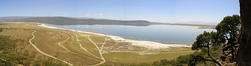
white rhinos.
The park has recently been enlarged partly to provide the sanctuary for the black rhinos. This undertaking has necessitated a fence - to keep out poachers rather than to restrict the movement of wildlife. The park marches for 12.1 km on the south eastern boundary with the Soysambu conservancy which represents a possible future expansion of habitat for the rhinos and the only remaining wildlife corridor to Lake Naivasha.
The park now (2009) has more than 25 eastern black rhinoceros, one of the largest concentrations in the country, plus around 70 southern white rhinos. There are also a number of Rothschild's giraffe, again relocated for safety from western Kenya beginning in 1977. Waterbuck are very common and both the Kenyan subspecies are found here. Among the predators are lions, cheetahs and leopards, the latter being seen much more frequently in recent times. The park also has large sized pythons that inhabit the dense woodlands, and can often be seen crossing the roads or dangling from trees.
As well as flamingos, there are myriad other bird species that inhabit the lake and the area surrounding it, such as African fish eagle, Goliath heron, hamerkop, pied kingfisher and Verreaux's eagle among others of their kind.
Habitat and Wildlife
White Rhinos
 Lake
Nakuru, a small (it varies from 5 to 45 square kilometers) shallow
alkaline lake on the southern edge of the town of Nakuru lies about 164
kilometers north of Nairobi. It can therefore be visited in a day tour
from the capital or more likely as part of a circuit taking in the Masai
Mara (Also Maasai Mara) or Lake Baringo and east to Samburu. The lake
is world-famous as the location of the greatest bird spectacle on earth -
myriads of fuchsia pink flamingos whose numbers are legion, often more
than a million - or even two million. They feed on the abundant algae,
which thrives in the warm waters. Scientists reckon that the flamingo
population at Nakuru consumes about 250,000 kg of algae per hectare of
surface area per year.
Lake
Nakuru, a small (it varies from 5 to 45 square kilometers) shallow
alkaline lake on the southern edge of the town of Nakuru lies about 164
kilometers north of Nairobi. It can therefore be visited in a day tour
from the capital or more likely as part of a circuit taking in the Masai
Mara (Also Maasai Mara) or Lake Baringo and east to Samburu. The lake
is world-famous as the location of the greatest bird spectacle on earth -
myriads of fuchsia pink flamingos whose numbers are legion, often more
than a million - or even two million. They feed on the abundant algae,
which thrives in the warm waters. Scientists reckon that the flamingo
population at Nakuru consumes about 250,000 kg of algae per hectare of
surface area per year.
In recent years, there have been wide variations between the dry and wet seasons' water levels. It is suspected that this is caused by increasing watershed land conversion to intensive crop production and urbanization, both which reduce the capacity of soils to absorb water, recharge ground water and thus increase seasonal flooding. Pollution and drought destroy the flamingos' food, Cyanobacteria, or blue-green algae, and causing them to migrate to the nearby Lakes, more recently lakes Elmenteita, Simbi Nyaima and Bogoria. Local climate changes have also been hypothesized to contribute to the changing environmental conditions in the lakes catchment. Recent media reports indicate increasing concern among stakeholders, as mass flamingo migrations and deaths could spell doom to the tourism industry.
The flamingos feed on algae, created from their droppings mixing in the warm alkaline waters, and plankton. But flamingo are not the only avian attraction, also present are two large fish eating birds, pelicans and cormorants. Despite the tepid and alkaline waters, a diminutive fish, Alcolapia grahami has flourished after being introduced in the early 1960s. The lake is rich in other bird life. There are over 400 resident species on the lake and in the surrounding park. Thousands of both little grebes and white winged black terns are frequently seen as are stilts, avocets, ducks, and in the European winter the migrant waders.
Zooplankton: The monogonont rotifer species Brachionus sp. Austria (belonging to the Brachionus plicatilis cryptic species complex) occurs in the lake.
Malindi Marine National Park
Malindi
Marine National Park is located in the Indian Ocean, off the coast of
Kenya. It is claimed to be oldest marine park in Africa. The park lies
at Malindi, about 118 km north of Mombasa and is protected and
administered by the Kenya Wildlife Service. Along with Watamu Marine
National Park, Malindi Marine Park is enclosed by the Malindi Marine
National Reserve.
Malka Mari National Park Malka Mari National Park
is a national park of Kenya, situated along the Daua river on the
Kenya-Ethiopia border. It is approximately 1,500 square kilometres
(370,000 acres) in size. It is accessible via the Mandera Airport, and
is probably the least visited national park in the nation.
The park is mostly semi-arid bushland and scrubby grassland with riparian woodland and along the river. There are plants in the park that are unique to the area.
Malka Mari is a IUCN Category II park designated in 1989.
The park is mostly semi-arid bushland and scrubby grassland with riparian woodland and along the river. There are plants in the park that are unique to the area.
Malka Mari is a IUCN Category II park designated in 1989.
Masai Mara National Park
TheMaasai Mara (also known as the Masai Mara, and locally
simply as The Mara) is a large game reserve in Narok County, Kenya,
contiguous with the Serengeti National Park in Tanzania. It is named in
honor of the Maasai people
(the ancestral inhabitants of the area) and their description of the
area when looked at from afar: "Mara" means "spotted" in the local
Maasai language of Maa, due to the many trees which dot the landscape.
It is world-renowned for its exceptional populations of lions, leopards, cheetahs and elephant, and the annual migration of wildebeest, zebra, Thomson's gazelle and other antelope, to and from the Serengeti every year known as the Great Migration.
The Greater Mara Ecosystem encompasses areas known as the Maasai Mara National Reserve, the Mara Triangle, and several Maasai Conservancies, including: Koiyaki, Lemek, Ol Chorro Oirowua, Olkinyei, Siana, Maji Moto, Naikara, Ol Derkesi, Kerinkani, Oloirien, and Kimintet.
History
When it was originally established in 1961 as a wildlife sanctuary the Mara covered only 520 km2 (200 sq mi) of the current area, including the Mara Triangle. The area was extended to the east in 1961 to cover 1,821 km2 (703 sq mi) and converted to a game reserve. The Narok County Council (NCC) took over management of the reserve at this time. Part of the reserve was given National Reserve status in 1974, and the remaining area of 159 km2 (61 sq mi) was returned to local communities. An additional 162 km2 (63 sq mi) were removed from the reserve in 1976, and the park was reduced to 1,510 km2 (580 sq mi) in 1984.In 1994, the TransMara County Council (TMCC) was formed in the western part of the reserve, and control was divided between the new council and the existing Narok County Council. In May 2001, the not-for-profit Mara Conservancy took over management of the Mara Triangle.
 Geography

The terrain of the reserve is primarily open grassland with seasonal riverlets. In the south-east region are clumps of the distinctive acacia tree. The western border is the Esoit (Siria) Escarpment of the East African Rift, which is a system of rifts some 5,600 km (3,500 mi) long, from Ethiopia's Red Sea through Kenya, Tanzania, Malawi and into Mozambique. Wildlife tends to be most concentrated here, as the swampy ground means that access to water is always good, while tourist disruption is minimal. The easternmost border is 224 kilometres (139.2 mi) from Nairobi, and hence it is the eastern regions which are most visited by tourists.
Altitude: 1,500–2,180 m (4,920–7,150 ft); Rainfall: 83 mm (3.3 in)/month; Temperature range: 12–30 °C (54–86 °F)
Wildlife

All members of the "Big Five" (lion, leopard, elephant, cape buffalo, and rhinoceros) are found here. The population of black rhinos was fairly numerous until 1960, but it was severely depleted by poaching in the 1970s and early 1980s, dropping to a low of 15 individuals. Numbers have been slowly increasing, but the population was still only up to an estimated 23 in 1999.
Hippopotami and crocodiles are found in large groups in the Mara and Talek rivers. Hyenas, cheetahs, jackals, and bat-eared foxes can also be found in the reserve. The plains between the Mara River and the Esoit Siria Escarpment are probably the best area for game viewing, in particular regarding lion and cheetah.
As in the Serengeti, the wildebeest are the dominant inhabitants of the Masai Mara, and their numbers are estimated in the millions. Around July of each year, these animals migrate north from the Serengeti plains in search of fresh pasture, and return to the south around October. The Great Migration is one of the most impressive natural events worldwide, involving some 1,300,000 wildebeest, 500,000 Thomson's gazelles, 97,000 Topi, 18,000 elands, and 200,000 zebras.
Antelopes can be found, including Grant's gazelles, impalas, duikers and Coke's hartebeests. The plains are also home to the distinctive Masai giraffe. The large roan antelope and the nocturnal bat-eared fox, rarely present elsewhere in Kenya, can be seen within the reserve borders.
More than 470 species of birds have been identified in the park, many of which are migrants, with almost 60 species being raptors. Birds that call this area home for at least part of the year include: vultures, marabou storks, secretary birds, hornbills, crowned cranes, ostriches, long-crested eagles, African pygmy-falcons and the lilac-breasted roller, which is the national bird of Kenya.
Meru National Park Meru
National Park is a Kenyan national park located east of Meru, 350 km (220 mi) from Nairobi. Covering an area of 870 km2
(340 sq mi), it is one best known national parks in Kenya. Rainfall in
this area is abundant with 635–762 mm (25.0–30.0 in) in the west of the
park and 305–356 mm (12.0–14.0 in) in the east. The rainfall results in
tall grass and lush swamps.
i love kenya ��������
ReplyDeletewhere is kenya?
ReplyDeletewell explined @zimbermanne
ReplyDeletekenya...
ReplyDelete